असन्ते साम्राज्य
| Kingdom of Ashanti Asanteman (Ashanti) | ||||||
| State union | ||||||
| ||||||
| ||||||
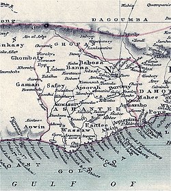 Map of the Kingdom of Ashanti | ||||||
| राजधानी | Kumasi | |||||
| भाषाएँ | Ashanti (Twi) (official) | |||||
| धार्मिक समूह | Christianity | |||||
| शासन | Monarchy | |||||
| राजा | ||||||
| - | 1670–1717 (first king) | Osei Tutu | ||||
| - | 1888–1896 (13th king of the indep. Ashanti Kingdom) | Prempeh I | ||||
| - | 1931–1957 (last king of the indep. Ashanti Kingdom) | Prempeh II | ||||
| - | 1999–present (Ashanti region absolute monarchy national state within Ghana) | Osei Tutu II | ||||
| विधायिका | Asante Kotoko (Council of Kumasi)[1] & the Ashanti Kingdomhyiamu (National Assembly) | |||||
| इतिहास | ||||||
| - | स्थापित | 1670 | ||||
| - | Independence from Denkyira | 1701 | ||||
| - | British colony | 1896 | ||||
| - | Self-Rule | 1935 | ||||
| - | State union as Ashanti Region with Ghana | 1957 | ||||
| - | State union | Present | ||||
| क्षेत्रफल | ||||||
| - | 1874[2] | 2,59,000 किमी ² (1,00,000 वर्ग मील) | ||||
| जनसंख्या | ||||||
| - | 1874[2] est. | 30,00,000 | ||||
|
| 11.6 /किमी ² (30 /वर्ग मील) | |||||
| मुद्रा | ||||||
| आज इन देशों का हिस्सा है: | ||||||

असन्ते साम्राज्य या अशांती साम्राज्य वर्तमान अफ़्रिका के घाना देश में सन १६७० से १९५७ तक था।